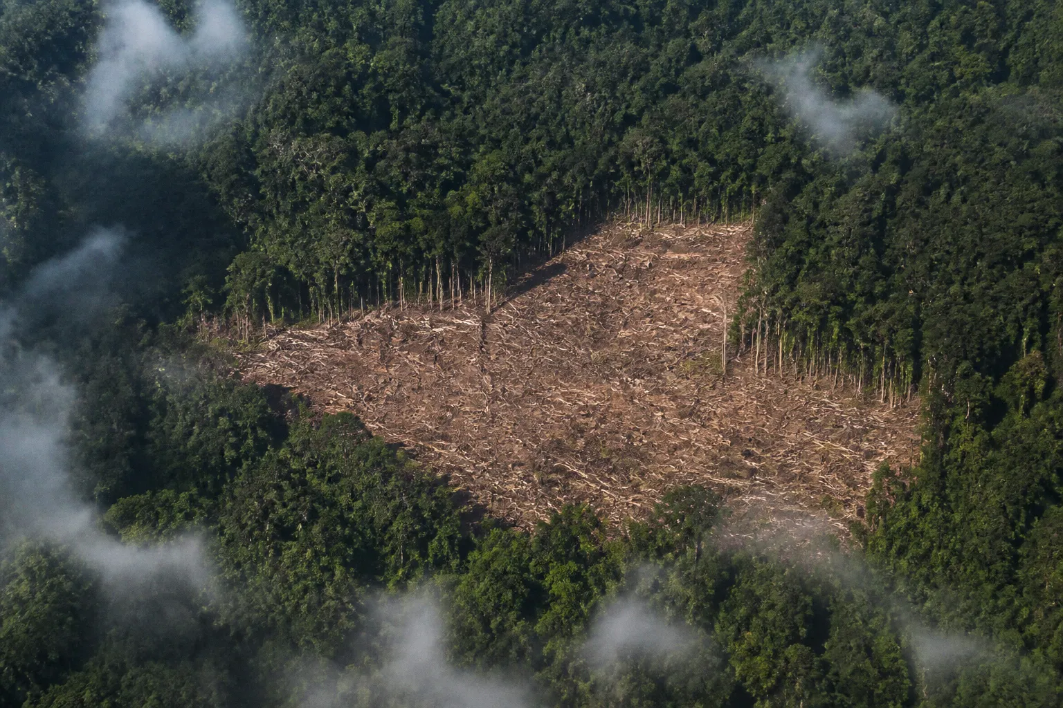
On the ground, however, the forest has often disappeared before the monitoring system has finished waiting for a clear image.
That contradiction is becoming harder to defend. Radar satellite deforestation monitoring can detect forest disturbance through tropical cloud cover, haze, rain, and darkness, reducing the average detection lag in comparative testing to 24.3 days. Optical systems, constrained by persistent cloud cover, recorded delays of 87 days for GLAD alerts and up to 286 days for PRODES in the same broad problem space. A forest cleared in three months is not a reporting technicality. It is a completed political fact.
Synthetic Aperture Radar, or SAR, has therefore moved from specialist remote-sensing infrastructure into the operational machinery of conservation, deforestation compliance, and carbon-market scrutiny. The technology is not infallible, free of false positives, or magically capable of telling a logging road from every other change in a wet tropical landscape. It is simply much less willing than optical monitoring to wait for the atmosphere to cooperate.
The cloud barrier: why optical satellites struggle in the tropics
Optical satellite imagery remains indispensable. When skies are clear, it provides spectral information that radar cannot replicate, including data used to assess vegetation condition through indices such as NDVI. It can help distinguish vegetation types, burned areas, bare soil, plantations, and other land-cover categories with a visual and spectral clarity that is valuable for both scientific analysis and enforcement.
The difficulty is that many of the forests most exposed to clearing are located in regions where clear skies are not a dependable operating condition.
Optical sensors record reflected sunlight. Dense cloud, haze, and heavy atmospheric moisture can obscure the surface, turning a satellite pass into a photograph of the weather rather than the land. A monitoring program may receive frequent orbital coverage and still struggle to produce a usable sequence of images. The satellite is technically present; the evidence is not.
This creates a delay that is often described in administrative language: a processing gap, a confirmation period, an alert latency. Such terms are neat, bloodless, and useful for grant applications. They conceal the practical consequence. During the gap, roads can be extended, timber extracted, fires set, and the cleared area absorbed into a new agricultural or industrial perimeter.
The problem is not limited to remote forests with no observers. It affects any enforcement system that depends on a reliable chain between disturbance, alert, verification, and intervention. A forest agency may have a legal mandate to stop unauthorized clearing, while its monitoring feed is still waiting for a cloud-free acquisition. A buyer may have a no-deforestation commitment, while the relevant parcel remains hidden beneath weather. A carbon project may advertise permanence and additionality, while its baseline landscape is changing faster than its reporting cycle.
A satellite can pass over a forest every few days and still fail to see the clearing that matters. Orbital frequency is not the same thing as usable evidence.
Radar changes the terms because it does not depend on reflected visible light. It emits microwave signals and measures the returned signal, known as backscatter. The resulting observation is not a conventional photograph. It is a record of how the surface and vegetation interact with the radar pulse, including changes in structure, moisture, and roughness.
That distinction is less cinematic than a satellite image with a bright red polygon around a fresh clearing. It is also more useful when clouds are doing what clouds routinely do in the tropics.
How active microwave sensors see through canopy and haze
Synthetic Aperture Radar systems operate as active microwave instruments. They transmit their own signal, which means they can work at night and do not require daylight. Their microwave wavelengths also pass through cloud and haze, allowing observations under conditions that interrupt optical monitoring.
Sentinel-1, operated within Europe’s Copernicus programme, has become central to this shift. Its C-band SAR sensors provide imagery at a spatial resolution of 10 metres, a scale suited to detecting many forms of forest disturbance while retaining broad global coverage. Operational systems such as RADD — Radar for Detecting Deforestation — use Sentinel-1 data to generate near-real-time disturbance alerts in tropical forests.
The term “near-real-time” deserves the usual diplomatic caution. It does not mean that a ranger receives an exact, legally conclusive account of a chainsaw’s location at the instant it starts. Radar observations still require acquisition, processing, change detection, quality control, and interpretation. Moisture variations, sensor noise, seasonal changes, and other land-surface effects can generate confusing signals. The alert is a prompt for action, not the action itself.
Still, the operational advantage is substantial. SAR data provide a more regular stream of observations in landscapes where optical systems are intermittently blinded. Repeated images can be compared to identify changes in the radar response associated with clearing, logging, infrastructure expansion, or other disturbances.
The basic logic is straightforward:
1. A radar sensor records the forest’s structural and moisture-related signal.
2. A later acquisition is compared with the earlier baseline.
3. A significant change is flagged as a possible disturbance.
4. Analysts, agencies, or field teams assess whether the alert represents deforestation, degradation, harvesting, flooding, agricultural activity, or another change.
5. The alert can then feed enforcement, supply-chain review, concession oversight, or project monitoring.
The sophistication lies in the exceptions. Forest landscapes are not static surfaces, and radar does not turn them into static surfaces merely because it can see through clouds. Heavy rain, changes in canopy moisture, wind damage, flooding, and temporary disturbance can all influence backscatter. A serious monitoring system must therefore interpret patterns across time rather than treat a single anomalous pixel as proof of illegal clearing.
This is where algorithm design becomes more than a technical footnote. The same radar imagery can produce very different results depending on the change-detection method, the calibration of thresholds, the reference data used for validation, and the geography in which the model is applied. An algorithm trained on one type of tropical forest may perform differently in another region, especially where canopy structure, soil moisture, agricultural practices, and logging patterns diverge.
The market prefers a simple claim: radar sees through clouds. The field requires a more complicated one: radar sees through clouds, provided the system understands what else may be changing underneath them.
Quantifying the speed advantage: SAR against optical lag
Speed is the most politically consequential advantage of radar satellite forest monitoring. Accuracy attracts technical panels; speed determines whether an alert can still matter.
Comparative testing has recorded an average deforestation detection lag of 24.3 days for SAR-based monitoring, including systems such as Satelligence. By contrast, optical monitoring delays reached 87 days for GLAD and as much as 286 days for PRODES under conditions where cloud cover obstructed timely observation.
These figures should not be flattened into a universal promise that every SAR alert will arrive in 24.3 days or that every optical alert will take 286. The figures describe comparative performance under particular systems and conditions. They are useful precisely because they show the scale of the operational gap, not because they provide a magical timetable for every forest on Earth.
| Monitoring characteristic | Optical satellite systems | SAR radar systems |
|---|---|---|
| Dependence on daylight | Generally required | Not required; the sensor emits its own microwave signal |
| Effect of tropical cloud cover | Can prevent usable surface observation | Microwave signals can operate through cloud and haze |
| Typical evidence type | Spectral and visual information | Structural and moisture-related backscatter changes |
| Comparative detection lag | Can reach 87 days or more under difficult conditions; up to 286 days reported for PRODES | 24.3 days average in comparative testing |
| Key strength | Vegetation and land-cover characterization, including spectral indices | Frequent disturbance detection despite cloud and darkness |
| Main limitation | Weather-dependent acquisition | Signal noise, moisture effects, and the need for interpretation |
| Best operational role | Confirmation, classification, and ecological assessment | Early warning and repeated change detection |
The difference matters most in places where clearing proceeds quickly. An alert arriving after a few weeks can support a site visit, a permit review, a supply-chain suspension, or a request for explanation while the disturbance is still legible on the ground. An alert arriving after several months may confirm a loss that no longer has an obvious point of intervention.
This is also where corporate commitments begin to encounter their own carefully constructed language. “Zero deforestation” policies, responsible sourcing frameworks, and sustainability pledges typically depend on monitoring systems capable of identifying what happened, where it happened, and when it happened. If the timestamp is vague, the pledge becomes difficult to enforce. If the parcel boundary is uncertain, responsibility can be passed between concessionaires, suppliers, intermediaries, and the familiar administrative fog of shared accountability.
For companies exposed to regulation or reputational risk, radar offers something more valuable than ecological insight: a shorter interval between alleged misconduct and discoverable evidence. That is why the technology is increasingly relevant to commodity supply chains, forest concessions, conservation finance, and carbon projects. The relevant question is not merely whether a company can produce a map. It is whether the map arrives before the forest loss becomes irreversible and before the paperwork catches up.
The same logic applies to carbon markets. A project that claims avoided deforestation must demonstrate that the threatened forest remains standing and that any reported losses are captured promptly. A monitoring system with long blind periods creates room for uncertainty around baselines, leakage, project boundaries, and permanence. Radar does not resolve those problems, but it narrows one of the most convenient excuses: that nobody could see what was happening.
Precision metrics: what accuracy figures actually tell us
The phrase “radar satellite deforestation monitoring accuracy” sounds like a single number waiting to be placed in a press release. It is not. Accuracy depends on what is being measured, what counts as a positive detection, how reference data were assembled, and whether the test concerns a carefully selected study area or a global operational dataset.
Several metrics in the available research illustrate the distinction.
Evaluations of Sentinel-1 C-band SAR change-detection algorithms achieved a change-detection sensitivity, also called producer’s accuracy, of 96.5%, with a balanced accuracy of 90.4%. Those are strong results, but they answer different questions.
- Producer’s accuracy asks how many of the real changes in the reference data were successfully detected. A high value suggests that the system misses relatively few changes in the tested setting.
- User’s accuracy asks how many of the alerts issued by the system correspond to real changes. It is closely related to the practical burden of false positives.
- Balanced accuracy accounts for performance across classes, which matters when unchanged forest greatly outnumbers disturbed land.
- Minimum mapping unit describes the smallest area the dataset is designed to map, not the guaranteed size of every reliably detected event.
These distinctions become especially important when comparing a model designed for a research benchmark with a global alert product intended to operate across continents.
The Sentinel-1-based Land Use Change Alert, or LUCA, dataset maps near-real-time global forest changes every two weeks, using a minimum mapping unit of 0.05 hectares. Its reported average area-adjusted user’s accuracy is 83%, while producer’s accuracy is 63%.
At first glance, the two numbers may look disappointing beside a 96.5% sensitivity figure. That would be the wrong conclusion. They describe different products, methods, scales, and evaluation conditions. The LUCA figures indicate that a meaningful share of alerts correspond to mapped change, while the lower producer’s accuracy indicates that the system does not capture every relevant change. Global coverage is not a laboratory demonstration; it is a compromise with geography, seasonality, sensor conditions, and the unruly diversity of forest landscapes.
Deep-learning systems complicate the picture further. Advanced spatio-temporal neural networks, including U-Net architectures applied to multi-temporal Sentinel-1 SAR stacks, have demonstrated logging-detection accuracies of approximately 95% in research settings. Such results show what the data and model design can achieve under defined conditions. They do not establish that every operational deployment will reproduce the same performance.
The temptation to transfer a research percentage directly into a global conservation claim is strong because percentages travel well. They fit into executive summaries, investor decks, procurement documents, and the increasingly elaborate architecture of environmental, social, and governance reporting. But an accuracy figure without its validation context is not transparency. It is decorative compliance.
A responsible interpretation asks at least four questions:
1. What event is being detected? Clear-cutting, selective logging, forest degradation, fire damage, road construction, and plantation conversion do not produce identical radar signatures.
2. What is the reference dataset? A model validated against carefully labelled imagery may perform differently when deployed across regions with limited ground truth.
3. What is the cost of a false negative? Missing a small clearing inside a protected area may be more consequential than generating an extra alert in a managed landscape.
4. How quickly can an alert be reviewed? A technically accurate system that overwhelms agencies with unverified alerts may become operationally useless.
The final question is the least glamorous and perhaps the most important. Detection is not protection. A map can identify a disturbance, but it cannot cancel a permit, prosecute an operator, secure a border, compensate a community, or restore a wetland. Those tasks remain stubbornly terrestrial, institutional, and vulnerable to the interests that made the clearing profitable.
The impressive number is not the percentage printed beside an algorithm. It is the time left to do something after the alert arrives.
From radar alert to enforcement: the operational reality
The practical value of SAR monitoring depends on what happens after detection. A real-time satellite forest alert is only the first link in a chain that includes jurisdiction, authority, field capacity, data access, and political willingness.
RADD and similar operational systems demonstrate the first part of the chain: cloud-free disturbance alerts can be produced for tropical forests using Sentinel-1 radar data. Other datasets, including LUCA, extend the logic to global, bi-weekly mapping. These systems can provide a common layer of information for forest agencies, conservation organisations, researchers, companies, and communities.
But common information does not automatically create common action.
An alert inside a protected area may trigger a different response from an alert inside a licensed concession. A detected change may be legal harvesting, an approved infrastructure corridor, smallholder expansion, fire damage, or illegal clearing. The satellite cannot decide which legal category applies. That requires access to permits, concession boundaries, land registries, management plans, and sometimes evidence gathered on the ground.
The quality of the response also depends on whether institutions can process alerts at the speed at which they are generated. A national agency may receive a technically sophisticated stream of warnings and lack the staff, transport, legal authority, or political backing to investigate them. A commodity buyer may have the monitoring platform but no effective mechanism for suspending a supplier. A conservation project may publish alert maps while treating the underlying community dispute as an inconvenient data anomaly.
This is where the financial architecture becomes visible. The technology itself may be built on open-access data, including Copernicus Sentinel-1, but operational monitoring still requires computing, algorithm development, validation, analysts, interfaces, field verification, and institutional integration. The exact cost difference between purely commercial SAR constellations and free open-access datasets remains context-dependent. The free image is not the free monitoring system.
There is also a risk that radar becomes another layer in the expanding market for environmental assurance: a technical credential attached to a claim that remains politically weak. A company can cite continuous monitoring and still avoid publishing concession-level results. A carbon programme can report regular alerts and still rely on contested baselines. A government can announce a forest-protection framework that is technically well monitored but legally non-binding, underfunded, or selectively enforced.
The existence of better evidence raises the standard for excuses. It does not necessarily raise the standard for conduct.
For conservation organisations, SAR is most useful when integrated with other forms of evidence rather than treated as a replacement for them. Optical imagery can help classify the disturbance. High-resolution commercial imagery can support verification. Field teams can establish what actually happened. Local and Indigenous communities may know whether a mapped change reflects a long-standing land-use practice, a permitted operation, or a new intrusion that the satellite has merely rendered visible to distant institutions.
The most robust system is therefore not radar alone. It is a layered arrangement in which radar supplies speed and continuity, optical data supply spectral context, field or local evidence supplies interpretation, and legal institutions supply consequences.
That last layer is where many sustainability frameworks become strangely quiet.
The new standard is a more demanding question
Radar satellite deforestation tracking is becoming a new operational standard because it solves a problem that optical systems cannot solve consistently: observing forest disturbance when the atmosphere refuses to provide a clear view. Sentinel-1 SAR data can operate day and night, penetrate cloud and haze, and support alerts at intervals measured in weeks rather than seasons. In comparative testing, the speed advantage is not marginal.
Yet the technology’s rise should not be confused with the end of uncertainty. SAR can produce false positives. It can miss changes. Accuracy varies between research models and global datasets. A 96.5% sensitivity result, a 90.4% balanced accuracy figure, and LUCA’s 83% user’s accuracy and 63% producer’s accuracy are not interchangeable badges of certainty. They are measurements of different arrangements of data, algorithms, and objectives.
The real achievement is more modest and more consequential: radar shortens the period during which forest loss can remain invisible. That makes enforcement more plausible, supply-chain claims more testable, and carbon-market accounting less comfortable. It also removes one of the oldest conveniences in environmental governance — the ability to say that the evidence arrived too late to matter.
The remaining question is not whether satellites can see more. They can. It is whether the institutions receiving that evidence are prepared to see what it implicates: permits, financiers, buyers, regulators, and the so-called frameworks that have spent years promising forests a future in non-binding language. A clearer view of the forest may only make the old bargain harder to disguise.